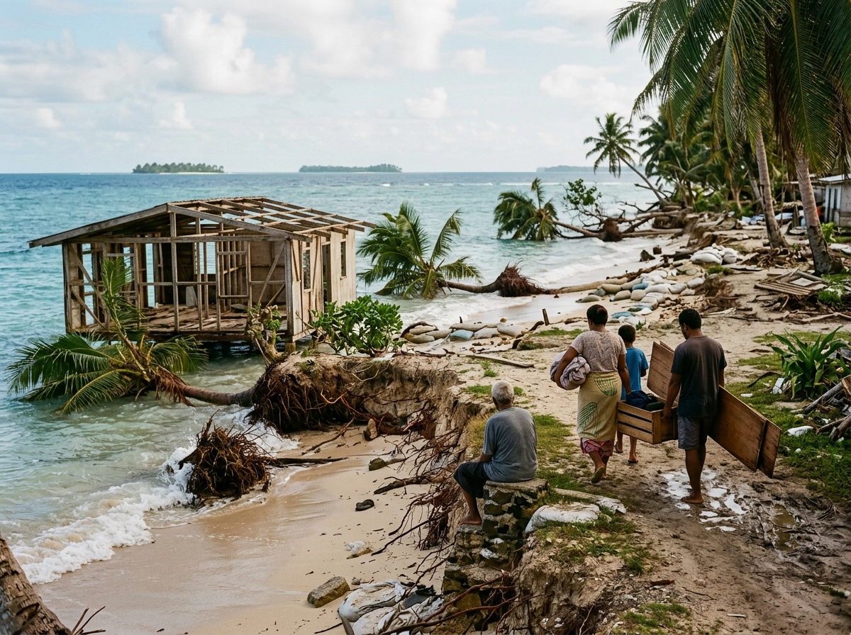
For most of human history, coastlines appeared permanent.
Villages were built beside the sea. Families lived on the same islands for generations. Ports grew into cities. Coconut trees marked shorelines. Cemeteries, temples, churches, schools, farms and ancestral homes became part of the landscape.
Now, in many places, the boundary between land and sea is moving.
Sea level is rising globally as the planet warms. Glaciers and ice sheets are losing mass, while seawater itself expands as it heats. NASA's latest satellite-based indicator shows that global mean sea level has risen by about 100.7 millimeters — roughly 4 inches — since 1993, and the overall rate of rise has more than doubled during the satellite era.
Four inches may sound small. But a higher baseline allows storm surges to reach farther inland, high tides to flood more frequently, saltwater to enter groundwater and farmland, waves to erode coastlines more aggressively, wetlands to become submerged, drainage systems to fail more frequently, and low-lying islands to become increasingly difficult to inhabit.
For some communities, climate change is no longer a distant projection. It is becoming a question of: Can we continue living here?
Why Is Sea Level Rising?
Melting Land Ice
As temperatures rise, glaciers and large ice sheets lose ice. Important sources: the Greenland Ice Sheet, the Antarctic Ice Sheet and mountain glaciers. NASA estimates roughly two-thirds of global sea-level rise is being driven by melting land ice.
Thermal Expansion
Water expands as it warms. Oceans absorb an enormous amount of the excess heat accumulating in Earth's climate system. Across the enormous area and depth of the world's oceans, even a small percentage expansion translates into substantial sea-level rise.
Sea-Level Rise Is Accelerating
Sea level doesn't rise at exactly the same amount each year. NASA reported global mean sea level rose only 0.08 cm in 2025 (La Niña shifted large amounts of water onto land through rainfall over places such as the Amazon basin). In contrast, 2024 saw an unusually large increase of about 0.59 cm. Year-to-year variations do not change the long-term picture — the annual rate of rise has more than doubled over roughly three decades.
Weather creates temporary ups and downs. Climate determines the long-term direction. And the long-term direction is upward.
Global Sea Level Is Not the Same Everywhere
Relative sea level at a particular coastline can be influenced by land subsidence, land uplift, ocean currents, tides, atmospheric pressure, groundwater extraction, sediment loss, tectonic activity, and changes in gravity associated with melting ice sheets. A city built on sinking land can experience sea-level impacts considerably faster than the global average. Every coastal community needs local measurements, not simply the global average.
The Real Threat Is Not Only Permanent Submergence
A community may experience disruption long before land is permanently submerged:
- More frequent tidal flooding — roads that once flooded once a decade may begin flooding several times each year.
- Saltwater intrusion — salt can enter wells and underground freshwater supplies.
- Agricultural damage — saltwater reduces soil productivity and damages crops.
- Coastal erosion — beaches and protective dunes disappear.
- Septic and sewer problems — high groundwater makes sanitation systems increasingly difficult to operate.
- Storm-surge amplification — a storm begins from a higher sea level.
- Insurance and property loss — repeated flooding can make homes difficult to insure or finance.
Eventually the practical question may become less "Is this land technically above water?" and more "Can people safely and economically continue living here?"
Islands Are Especially Vulnerable
Low-lying islands and coral atolls face some of the world's most serious sea-level challenges. Many rise only a few meters above present sea level. At particular risk: Maldives, Kiribati, Tuvalu, Marshall Islands, Micronesia, Fiji, Solomon Islands, Bahamas, Caribbean island states, Indian Ocean islands, Pacific territories.
But "disappearing islands" needs careful interpretation. Some islands may physically shrink or disappear through erosion. Others may change shape. Coral islands can sometimes migrate or accumulate sediment. An island can remain visible while becoming increasingly difficult for people to inhabit because freshwater, housing, roads and agriculture fail.
Physical island survival is not necessarily the same thing as human habitability.
The Hidden Island Crisis: Fresh Water
Many small islands rely on a thin underground layer of freshwater created by rainfall, floating above denser saltwater beneath the island — the freshwater lens. Sea-level rise, drought, storm surge and excessive groundwater pumping can cause saltwater contamination. Once wells become salty, communities may depend increasingly on rainwater collection, desalination or imported water. Freshwater loss may force relocation before permanent flooding does.
Saltwater and Agriculture
Salt can damage taro, coconut production, vegetables, fruit trees and freshwater wetlands. A community losing agricultural land may become increasingly dependent on expensive imported foods.
Erosion Destroys Cultural History
Coastal erosion is not simply a loss of square meters of land. The disappearing edge may contain family homes, cemeteries, sacred places, archaeological sites, community meeting areas and historical villages. For Indigenous and island peoples, relocation can mean losing physical connections to ancestry and culture.
Islands Can Disappear Suddenly
Sea-level rise is gradual, but storms can transform low islands extremely quickly. NOAA documented how East Island in the Northwestern Hawaiian Islands was largely washed away during Hurricane Walaka in 2018 — later partially rebuilding naturally as sand and gravel returned. An island may erode dramatically, migrate or rebuild rather than simply sink vertically beneath the sea.
Nations on the Front Line
- The Maldives — hundreds of low-lying coral islands. Tourism, housing, airports and infrastructure concentrated very close to sea level. Adaptation must occur across geographically dispersed islands.
- Tuvalu — the concern involves more than whether islands remain above water. What happens to a nation if significant numbers of its citizens eventually live elsewhere? Can citizenship, sovereignty, fishing rights and cultural identity survive physical displacement?
- Kiribati — low coral atolls across a vast area of the central Pacific. Strategies range from protecting communities in place to creating opportunities for migration with dignity — education + employment + legal migration opportunities + infrastructure + community choice.
- Marshall Islands — high tides and storm waves can cross narrow atolls. Communities whose history, culture and identity are deeply tied to particular islands face especially painful choices.
- Fiji — has become an important example of planned community relocation, in which entire villages may move rather than families individually abandoning their community. Attempts to preserve social connections, traditional leadership, community institutions and cultural identity.
Relocation Is Much More Than Moving Houses
Communities contain an entire social ecosystem. Relocation involves land ownership, employment, schools, healthcare, transportation, cemeteries, religious and cultural places, and identity itself. Is a fishing community still the same community when moved away from the ocean? These are deeply human questions — not merely engineering decisions.
Rehabilitation and Resettlement
When relocation becomes necessary, it should ideally be approached as community rehabilitation rather than merely physical evacuation: safe land · permanent housing · property rights · jobs · schools · healthcare · transportation · communications · water · sanitation · electricity · cultural facilities · places of worship · community gathering areas · compensation · mental-health and social support.
Most importantly: affected communities should participate in deciding their future.
Voluntary vs. Forced Relocation
Relocation is far more successful when communities understand the risk, participate in planning, have realistic alternatives, receive secure land rights, maintain livelihoods and can stay together if they choose. Forced displacement without these protections can create a second disaster after the environmental one.
Climate Migration Will Extend Far Beyond Islands
The World Bank's Groundswell work emphasizes that climate impacts are already influencing migration and that most climate-related movement is expected to occur within countries rather than across international borders. It also warns that some of the most vulnerable people may be unable to move at all, effectively becoming trapped in increasingly dangerous locations.
Climate pressures: sea-level rise · drought · water scarcity · crop failure · extreme heat · flooding · wildfires · storms.
Coastal Megacities Are Also at Risk
This is not only an island problem. Coastal megacities at some level of risk include Mumbai, Kolkata, Chennai, Kochi, Dhaka, Bangkok, Jakarta, Manila, Shanghai, Guangzhou, Ho Chi Minh City, Tokyo, New York, Miami, New Orleans, Lagos, Alexandria, Amsterdam.
- Jakarta — parts have experienced substantial land subsidence from groundwater extraction. When land sinks while the ocean rises, the relative change becomes much faster. Local land management and groundwater policy matter alongside global climate policy.
- New Orleans — low elevation, subsidence, hurricanes, storm surge, wetland loss. Large engineering systems reduce risk but cannot eliminate it.
- Miami and South Florida — porous underlying limestone means simply building a taller seawall does not solve every problem when water can also move through underground rock.
Bangladesh and the Ganges-Brahmaputra Delta
Bangladesh illustrates the enormous human scale of low-lying coastal vulnerability. Much of the population lives in river and delta landscapes exposed to cyclones, river flooding, coastal flooding, erosion and saltwater intrusion. Unlike a small island state, relocating vulnerable communities could involve very large populations.
India and Sea-Level Rise
India has thousands of kilometers of coastline and many major coastal cities. Potentially vulnerable areas: West Bengal, Odisha, Andhra Pradesh, Tamil Nadu, Kerala, Karnataka, Goa, Maharashtra, Gujarat, Andaman and Nicobar Islands, Lakshadweep.
- Lakshadweep — India's low-lying coral islands face erosion, freshwater, coral reef health, storm impacts and sea-level rise.
- Kerala's coast — densely settled. Coastal erosion, high waves, storm effects, sea-level rise, backwater flooding, saltwater intrusion. Homes, fishing communities, roads and tourism infrastructure all affected. NaturePulse observations from the same Kerala beaches and backwaters over decades could provide a powerful visual record of shoreline change.
- Sundarbans — spans India and Bangladesh, contains the world's largest mangrove ecosystem. Sea-level rise, cyclones, salinity, erosion, river changes, human settlement pressure. Islands within the delta can lose land or change shape significantly.
Natural Coastal Defenses
- Mangroves — reduce wave energy, trap sediment, reduce erosion, provide wildlife habitat, store carbon, support fisheries. They cannot stop all storm surge or sea-level rise, but destroying them removes an important natural defense.
- Coral reefs — reduce wave energy before waves reach shore. When damaged by ocean warming, coral bleaching, pollution, destructive fishing and ocean acidification, coastal islands lose another layer of natural protection. Climate change creates a dangerous feedback: warmer ocean → coral damage → less coastal protection → more erosion → greater island vulnerability.
- Wetlands and salt marshes — absorb wave energy and store floodwater, but need space to migrate inland. If roads, seawalls and buildings block this movement, wetlands become trapped between development and rising water — coastal squeeze.
Adaptation Choices
- Protect — seawalls, levees, surge barriers, dunes, mangroves, beach nourishment. Seawalls can reflect wave energy, transfer erosion elsewhere, damage beaches and require expensive maintenance; eventually may be overtopped.
- Accommodate — learn to live with some water. Elevated homes, floodable parks, improved drainage, raised utilities, floating infrastructure.
- Retreat — move buildings and communities away from areas that become increasingly unsafe.
The correct solution depends on the location — often a combination of all three.
Managed Retreat
Planned movement away from vulnerable locations before repeated disasters force emergency abandonment. Controversial. People do not easily leave homes, neighborhoods, businesses, schools and ancestral land. But in some places, repeated rebuilding may eventually become less sustainable than relocation.
Who Pays for Relocation?
One of the most difficult climate-policy questions. Possible participants: national governments · local governments · international organizations · development banks · climate funds · insurance systems · donor countries. Low-income island states often contribute very little to historical global greenhouse-gas emissions yet face some of the most serious consequences. This has made climate finance and loss and damage central international issues.
A Country Could Lose Land but Not Its Identity
If citizens of a low-lying island state eventually live elsewhere: does the nation continue? What happens to territorial waters? Fishing rights? Maritime boundaries? Where does the government operate? How is citizenship preserved? Can cultural sovereignty continue? These unprecedented questions increasingly concern diplomats and international-law experts.
Climate Change Is Happening Differently Around the World
The IPCC's Sixth Assessment synthesis concludes that human activities have unequivocally caused global warming and that climate change is already affecting weather and climate extremes in every region of the world.
- Arctic — warming rapidly. Sea-ice loss, permafrost thaw, coastal erosion, ecosystem changes. NOAA notes that reduced sea ice, thawing permafrost and stronger erosion are already contributing to relocation challenges for some Alaska Native communities.
- Glaciers — mountain glaciers shrinking in many regions. Affects river flow, drinking water, agriculture, hydropower, tourism.
- Extreme heat — cities can become particularly dangerous because buildings and pavement retain heat.
- Drought — crop failure, livestock losses, reservoir decline, wildfires, migration.
- Wildfires — hotter and drier conditions increase risk in some regions.
- Agricultural change — planting seasons shifting, flowering happening earlier, rain arriving later, new pests, heat stress, crop varieties becoming unsuitable.
Climate Migration Does Not Always Mean International Migration
Residents may first move within the village → nearby higher ground → regional town → major city. Only some eventually cross national borders. Internal movement is expected to represent a large share of future climate-related migration.
Trapped Populations
Moving requires money, transportation, employment opportunities, legal rights and social connections. The poorest people may remain in the most dangerous places precisely because they cannot afford to relocate. Climate adaptation must address inequality.
NaturePulse and the Changing Coastline
Satellites provide extraordinary global information. Tide gauges measure sea level. Scientists study glaciers. But people living along the coastline observe changes that may never become part of permanent scientific records.
A fisherman may remember: *"The beach used to extend another 100 meters."*
A resident may say: *"Saltwater never entered this well when I was young."*
A farmer may observe: *"Coconut trees near the beach are dying."*
A family may photograph: *"Our ancestral home before and after repeated flooding."*
Coastal Observation Form
Location · GPS · country · state/province · district · village · beach/island name · date and time.
Observation type: high tide · coastal erosion · flooding · saltwater intrusion · beach loss · mangrove change · coral damage · storm surge · property damage · island change · relocation.
Photograph the Same Coastline Repeatedly
Same place · same direction · same season. 2027 wide sandy beach → 2032 beach considerably narrower → 2037 road exposed to waves → 2042 road relocated. Extraordinarily valuable environmental documentation.
Island Timeline
Each island page could display: historical coastline · current coastline · population · elevation · freshwater · vegetation · coral reef · erosion · flood observations · relocation · news · scientific research · community stories.
Document Relocation Stories
Preserve not only physical changes but human stories — original village · GPS · population · reason for relocation · date · new location · photos · interviews · community history · agriculture · cultural sites.
Before → Change → Relocation → Recovery
Village Before → Repeated Flooding → Erosion → Decision to Relocate → Construction of New Village → Families Move → Old Village Becomes Uninhabitable → New Community 10 Years Later. A historical record for future generations.
Why Documentation Matters
Climate change is often discussed through numbers — 1.5°C, millimeters per year, tons of carbon dioxide. But communities experience climate change as a flooded road, a dry well, a dying tree, a disappearing beach, a failed crop, a house moved inland, a cemetery being eroded by the sea. Those observations tell the human story behind the scientific measurements.
A Century From Now
Imagine a child in 2126 visiting NaturePulse. They select an island. They see:
- 2026 — photographs
- 2040 — flood observations
- 2055 — coastal retreat
- 2070 — village relocation
- 2100 — new shoreline
And perhaps they listen to an interview recorded decades earlier: *"This is where our family lived. The ocean was much farther away when I was a child."*
Climate Change Is Ultimately About People and Places
Sea-level rise is not simply water becoming higher. It is about where people can live, where farmers can grow food, where fishermen can maintain communities, where children can go to school, where ancestors are buried, where cultures can survive.
Some coastlines can be protected. Some buildings can be elevated. Some wetlands can be restored. Some communities will adapt where they are. Others may eventually have to move.
The challenge is to make that transition — where unavoidable — planned, humane, adequately financed and respectful of culture and community.
NaturePulse.net — Observe · Photograph · Measure · Remember · Preserve.
Record the coastline. Record the island. Record the village. Record the people. Record the change. Climate change may alter the geography of our world. NaturePulse can help ensure that the story of those places — and the people who called them home — is never lost.