For generations, people living near the coast understood flooding primarily as something associated with storms. A hurricane arrived. A cyclone pushed water inland. A river overflowed. Heavy rainfall overwhelmed drainage.
Today, another kind of flooding is becoming increasingly familiar in coastal communities: water appears even when there is no storm.
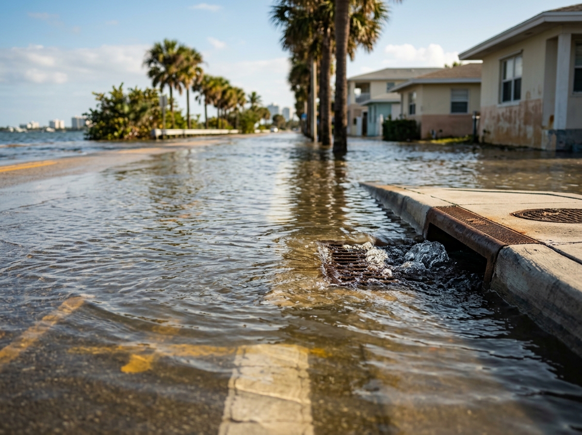
A road floods on a sunny afternoon. A parking lot fills with saltwater during an unusually high tide. Storm drains begin flowing backward. A neighborhood that rarely flooded decades ago begins experiencing water several times a year. The flooding may last a few hours and disappear again. Then it returns with the next high tide.
This phenomenon is commonly called high-tide flooding. It is also described as sunny-day flooding · nuisance flooding, or during especially high astronomical tides, king-tide flooding.
NOAA reports that annual occurrences of high-tide flooding have increased five- to tenfold since the 1960s in several U.S. coastal cities. As relative sea level rises, flooding happens more frequently and lasts longer. *(NOAA)*
The disturbing reality is simple: the ocean does not need a hurricane to reach places that used to remain dry.
The World's Oceans Are Rising
Sea-level rise is not a future theory. It is being measured now.
NASA's latest satellite indicator, updated in August 2026, places global mean sea level about 100.7 millimeters — roughly four inches — above the early-1990s satellite baseline. NASA's long-term record also shows that the annual rate of global sea-level rise has more than doubled over the satellite era.
Four inches may not sound dramatic. But the significance is not that every beach suddenly receives four inches of standing water. The importance is that the starting level of the ocean has risen.
Every high tide now begins from a slightly higher baseline. Every storm surge begins from a slightly higher baseline. Every wave reaches slightly farther inland. Every drainage system connected to the ocean must push water against a slightly higher sea level.
A few inches can therefore make the difference between water remaining inside a canal and water spilling into a street.
Why Is Sea Level Rising?
Two major processes dominate.
Melting Land Ice
Glaciers and the great Greenland and Antarctic ice sheets are losing ice. When ice that was stored on land enters the ocean, ocean volume increases.
NASA currently estimates that roughly two-thirds of long-term global sea-level rise is being driven by the addition of water from melting land ice.
Thermal Expansion
Water expands when it warms. The oceans absorb enormous quantities of heat from the warming climate system. As seawater warms, it occupies more space.
NASA reported that in 2024, unusually strong ocean warming made thermal expansion the dominant contributor to that year's larger-than-expected sea-level increase.
The Rate Is Accelerating
Perhaps the most concerning part of the story is not simply that sea level is rising. It is that the rate has accelerated.
NASA research found that the global rate increased from around 2.1 mm/year in 1993 to approximately 4.5 mm/year by 2023.
Year-to-year changes still occur. For example, global mean sea level rose relatively little in 2025 because La Niña shifted an unusual amount of ocean water onto land as rainfall, particularly over the Amazon basin. But NASA emphasizes that such short-term fluctuations sit on top of a persistent long-term rise.
The staircase may have small pauses. The staircase itself is still going upward.
Why Are Places Flooding at Different Times of the Day?
This is one of the most confusing aspects for residents. A person may say: *"It didn't rain. Why is my street flooded at 10 o'clock in the morning?"* Or: *"Yesterday the road was dry at noon, but today it flooded in the evening."*
The answer lies partly in the tides. Ocean tides rise and fall according primarily to the gravitational influence of the moon · sun · Earth's rotation · local coastal geography.
High tide therefore occurs at different times each day. The timing shifts. Some tides are higher than others. When the Sun, Earth and Moon align around new moon and full moon, tidal ranges can become larger.
Add a higher long-term sea level and suddenly a tide that once remained just below the road elevation begins spilling across it.
Flooding Without Rain
NOAA explains that high-tide flooding can occur when rising relative sea level combines with strong tides, ocean currents, winds and local geography — even under sunny skies.
That produces the strange experience coastal residents increasingly report: blue sky · no rainfall · no hurricane — and yet the street is underwater.
Yesterday's Storm Flood Can Become Tomorrow's Ordinary Tide
One of NOAA's most powerful descriptions is essentially this: as the sea rises, water levels that once occurred only during storms can eventually occur during ordinary high tides.
Think of a staircase. Thirty years ago:
- Normal tide: Step 1
- King tide: Step 2
- Road elevation: Step 3
- Storm surge: Step 4
The road usually remained dry. Now raise the entire ocean by another step:
- Normal tide: Step 2
- King tide: Step 3
- Road elevation: still Step 3
- Storm surge: Step 5
Suddenly a king tide floods the road without any storm. Continue raising the baseline and eventually more ordinary tides begin causing problems.
Miami: The World's Famous Sunny-Day Flooding Example
Few cities illustrate this better than Miami and Miami Beach. Miami Beach is very low lying · surrounded by water · built on highly permeable limestone · exposed to Atlantic and Biscayne Bay tides.
The city itself acknowledges that its low elevation creates flooding and drainage challenges from high tides, rainfall and storm surge. During autumn king tides, some low streets can experience ponding or flooding even in good weather. *(City of Miami Beach)*
Miami Has Another Problem: Water Can Come From Below
Building a seawall sounds like an obvious answer. But South Florida sits on porous limestone. Water can move through the underground geology. So a wall blocking direct ocean water does not necessarily prevent groundwater levels from rising behind it.
This makes South Florida's adaptation problem unusually complicated. Solutions may require combinations of elevated roads · pumps · stormwater valves · raised seawalls · improved drainage · higher buildings · groundwater management.
Miami Beach adopted a long-term sea-level-rise adaptation strategy in 2025, identifying tens of thousands of vulnerable assets and planning incremental adaptation over coming decades.
The U.S. Coast Is Entering a New Flooding Era
NOAA projects that relative sea level along the U.S. coast will rise, on average, approximately 10–12 inches between 2020 and 2050. That is about as much coastal sea-level rise in thirty years as the United States experienced during the previous century.
The rise is not equal everywhere. Projected regional averages by 2050 include approximately:
- Atlantic Coast: 10–14 inches
- Gulf Coast: 14–18 inches
- West Coast: 4–8 inches
- Caribbean: 8–10 inches
- Hawaii: 6–8 inches
Why the Gulf Coast Is Particularly Vulnerable
Sea-level rise combines with land subsidence in parts of Louisiana, Texas and Mississippi. When land sinks while the ocean rises, relative sea level increases faster.
Louisiana faces additional challenges from wetland loss · hurricanes · river engineering · sediment changes · oil and gas infrastructure. Communities may experience increasing flood exposure even without dramatic changes in individual storms.
Norfolk and Hampton Roads
Norfolk, Virginia, is another frequently cited U.S. example. The region faces rising ocean + sinking land + storms + tidal waterways. Military installations, roads, homes and commercial infrastructure are exposed. NOAA uses Norfolk as an example of a city where coastal flooding is becoming increasingly frequent.
Charleston, Savannah and Annapolis
High-tide flooding has also become familiar in Charleston, South Carolina · Savannah, Georgia · Annapolis, Maryland. NOAA has documented dramatic increases in the number of tidal flood days over past decades in several U.S. coastal cities.
Residents can increasingly encounter flooded downtown streets without a major hurricane anywhere nearby.
New York and the Northeast
New York City, Long Island, New Jersey and many northeastern coastal communities face increasing risks from sea-level rise · storm surge · heavy rainfall · high tides.
Hurricane Sandy demonstrated what happens when a severe storm surge arrives at a densely developed coastline. Higher future sea levels mean an equivalent storm would begin from a higher baseline.
California and the Pacific Coast
The U.S. West Coast is projected to experience less average rise by 2050 than the Atlantic and Gulf coasts, but this does not mean it is safe. California faces coastal erosion · beach loss · cliff instability · infrastructure exposure · high-tide flooding.
Large waves combined with high tides and rising seas can create substantial damage.
Hawaii and Pacific Islands
Islands face another dimension of risk. A relatively small rise in sea level can affect beaches · roads · freshwater · homes · tourism infrastructure · cultural sites. On narrow islands, there may be little room to move infrastructure inland.
India: Thousands of Kilometers of Vulnerable Coast
India has approximately 7,500 kilometers of coastline, much of it densely populated. Major coastal cities include Mumbai · Kolkata · Chennai · Kochi · Visakhapatnam · Surat · Mangaluru · Thiruvananthapuram.
A 2025 study of eight major Indian coastal cities projected growing sea-level and flood risks throughout this century, with particularly high exposure in low-lying, densely urbanized cities such as Mumbai, Kolkata and Chennai. Kochi, Mangaluru and Thiruvananthapuram were assessed as relatively less exposed in that particular model but still facing substantial future flooding risk. *(Nature)*
Indian Sea Levels Could Rise Substantially by 2100
Research presented by India's National Centre for Ocean Information Services under the Ministry of Earth Sciences projects that, under a high-emissions scenario, relative mean sea level at selected Indian coastal locations could rise roughly 0.62 to 0.87 meters by 2100, with projected extreme sea levels in the assessment reaching approximately 0.68 to 1.12 meters depending on location.
These are scenario-based projections, not predictions of exactly what will happen. But they illustrate the scale of adaptation coastal India may eventually need.
Kochi: A City Built With Water
Kochi is a particularly interesting case because water is part of the city's identity. The metropolitan landscape includes Arabian Sea · Vembanad backwaters · canals · rivers · estuaries · islands · wetlands.
Much of the area is low lying. A recent flood-resilience study describes Kochi as only around five meters above sea level overall, with an extensive network of rivers, backwaters, ponds and streams and increasing exposure to urban flooding and tidal-water intrusion. Some older western portions are much lower still.
Kochi Can Flood From Several Directions
Kochi's future flood risk is not simply *sea-level rise.* The city can experience combinations of heavy monsoon rain · backwater levels · river discharge · high tide · drainage congestion · coastal surge.
When high tide prevents drainage while intense rain falls on the city, water has nowhere to go quickly. This is sometimes called compound flooding.
Tidal Water Can Push Back Through Drainage
Urban drainage systems normally move rainwater toward *canal → river → estuary → sea.* But at unusually high tide, the downstream water level can rise. Then gravity drainage slows. In some systems water can even move backward.
The result: streets flood even though rainfall at that exact moment may be relatively light — or already finished. This is one reason residents can experience flooding at apparently strange times of day.
Sea Surges Along Kerala
Research published in 2025 examining Kerala sea-surge events from 2012–2023 found an increasing trend during the latter half of the study period, with Ernakulam district recording the highest number of events per 10 kilometers of coastline.
This does not mean every such event is caused solely by long-term sea-level rise. Coastal flooding can involve swell waves · tides · storm systems · coastal currents · local bathymetry. But a higher sea-level baseline makes these events more capable of reaching farther inland.
Kerala's Backwaters Make the Problem Unique
Unlike a simple open coastline, Kerala contains extensive interconnected backwaters. Sea-level changes can influence tidal exchange · estuaries · low islands · agricultural areas · salinity.
Kuttanad, for example, contains agricultural areas below mean sea level. Managing water there already requires bunds, pumps and controlled drainage. A changing sea level adds another long-term pressure.
Mumbai
Mumbai is built partly on low-lying reclaimed land and islands that were historically joined together. The city already experiences a dangerous combination when extreme monsoon rain coincides with high tide. Rainwater cannot drain rapidly into the sea when the receiving water is already high.
Future sea-level rise makes that drainage challenge increasingly difficult. The 2025 Indian coastal-city study identified Mumbai among the country's cities facing the greatest future coastal flood exposure.
Kolkata and the Sundarbans
Kolkata lies within the enormous Ganges-Brahmaputra-Meghna delta system. Nearby are the Sundarbans.
This region combines low elevation · river flooding · cyclones · storm surge · sea-level rise · land subsidence · salinity. Rural islands can lose homes · cropland · freshwater — while metropolitan areas face enormous infrastructure exposure.
Chennai
Chennai faces yet another combination: Bay of Bengal cyclones · storm surge · intense rainfall · river flooding · wetland loss · rapid urbanization. Sea-level rise adds another layer.
Coastal-city planning cannot therefore treat rainfall flooding and marine flooding as separate systems.
India's Islands
The problem becomes even more serious for Lakshadweep and Andaman & Nicobar Islands. Low coral islands have limited elevation and freshwater. As sea level rises: storm waves penetrate farther · beach erosion increases · freshwater lenses can become contaminated · infrastructure has less room to retreat.
Bangladesh: An Entire Delta Under Pressure
Bangladesh is one of the world's most frequently discussed sea-level-risk countries because much of it consists of a low-lying delta.
It faces river floods · cyclones · storm surge · erosion · salinity · sea-level rise. The concern is not that the entire country suddenly disappears. The more immediate problem is that progressively larger areas may face more frequent flooding + saltwater intrusion + agricultural disruption.
Maldives
The Maldives consists largely of extremely low coral islands. The country has pursued strategies including coastal defenses · land reclamation · artificially elevated islands · improved infrastructure.
But its long-term challenge illustrates the limits of conventional adaptation when an entire national territory remains close to sea level.
Tuvalu, Kiribati and the Marshall Islands
Low-lying Pacific island nations face similar challenges. An island need not disappear completely to become difficult to inhabit. Saltwater can contaminate freshwater before permanent inundation occurs. Roads can flood repeatedly. Storm waves can become more damaging.
Eventually the issue becomes *"can communities continue functioning safely?"* rather than simply *"is the island still visible?"*
Jakarta: Sea Rise Plus a Sinking City
Jakarta demonstrates another important global pattern: the sea can rise while the city sinks.
Groundwater extraction has caused substantial land subsidence in parts of the city. The World Bank has documented subsidence rates far exceeding global sea-level rise in some locations.
Jakarta therefore shows why global sea-level statistics alone do not tell a city's complete story.
Bangkok, Ho Chi Minh City, Manila, Shanghai
- Bangkok also sits on soft, low-lying delta sediments. Groundwater extraction historically contributed to significant subsidence. As with Jakarta, controlling land sinking can be just as important in the near term as addressing global sea-level rise.
- Ho Chi Minh City and the Mekong Delta combine low elevation · river flooding · land subsidence · sea-level rise · saltwater intrusion. The Mekong Delta is also one of Asia's most important agricultural regions. Rising salinity threatens rice production and freshwater supplies.
- Manila — metro Manila and surrounding areas face typhoons · storm surge · heavy rainfall · tidal flooding · subsidence. Historical groundwater extraction has contributed to substantial sinking in some parts of Manila Bay. Again: ocean rise + land subsidence = faster relative sea-level rise.
- Shanghai and China's coastal megacities — China's coast contains enormous concentrations of population · ports · industry · infrastructure. Cities around Shanghai, Guangzhou and the Pearl River Delta face long-term coastal risk. IPCC assessments identify Guangzhou and other Asian megacities among locations facing potentially enormous future economic exposure from rising seas.
Why Flooding Suddenly Appears in Places That "Never Flooded Before"
Residents understandably find this confusing. They may say: *"We have lived here for fifty years. This street never flooded."*
That does not contradict sea-level science.
Imagine a road surface sitting 15 centimeters above the highest ordinary tide. For decades: highest tide = road minus 15 cm. No flooding.
Then sea level rises 10 cm. Now: highest tide = road minus 5 cm. Add wind pushing water toward shore · abnormally high astronomical tide · low atmospheric pressure — and the threshold is crossed. Water appears on the street.
Nothing magical happened. A physical threshold was crossed.
Flooding Is a Threshold Problem
Imagine your front doorstep is 30 centimeters above today's normal highest tide. Sea-level rise does not need to reach 30 centimeters before causing trouble.
A future combination may be sea-level rise +10 cm · king tide +10 cm · onshore wind +5 cm · wave setup +5 cm — total +30 cm. Suddenly water reaches the door.
As baseline sea level rises, smaller and smaller temporary factors are needed to create the same flood.
Why Flooding Comes and Goes
Another confusing characteristic is that tidal flooding may disappear several hours later. Residents think: *"If sea level is rising, why did the water go away?"*
Because long-term sea-level rise and tides operate on different time scales. Sea-level rise raises the floor. Tides continue moving up and down above that floor.
When high tide arrives: flood. Several hours later: low tide → water drains away. Then another high tide arrives. This pattern can repeat daily during favorable tidal conditions.
Storm Drains Become Ocean Pathways
Cities often contain drainage pipes designed to discharge rainwater into bays · rivers · canals · ocean. At high tide, the receiving water can become higher than portions of the drainage network.
Without appropriate valves or pumping: the sea can enter through the drain. Residents may see seawater rising from storm drains into streets. This is increasingly familiar in low-lying coastal cities.
Sewage Systems Can Also Be Affected
High groundwater and repeated flooding can interfere with septic tanks · sewer pipes · pumping stations. Saltwater can accelerate corrosion. Floodwater entering sewage infrastructure can overwhelm treatment plants.
Sea-level adaptation therefore involves far more than protecting houses. It involves underground infrastructure most people never see.
Freshwater Is Also at Risk
Rising seas can push saltwater into groundwater · rivers · agricultural canals · wells. This process is saltwater intrusion.
A community may still be physically above sea level but lose reliable freshwater. For islands and agricultural deltas, this can become one of the earliest serious consequences.
Agriculture Near the Coast
Saltwater can damage rice · vegetables · fruit trees · soil. Coastal agriculture in Bangladesh · India · Vietnam · Indonesia and island nations may increasingly need salt-tolerant crops · freshwater management · barriers · changing planting patterns.
Sea-level rise therefore becomes a food-security issue.
Coastal Erosion
A rising ocean allows waves to reach farther inland. Beaches can migrate. Dunes can erode. Cliffs can retreat.
A house may never experience direct tidal flooding but still become unsafe because the coastline beneath it disappears.
Wetlands Need Somewhere to Go
Mangroves, salt marshes and wetlands can naturally migrate inland as sea level rises — if open land exists. But cities often place roads · seawalls · houses immediately behind them. The ecosystem becomes trapped.
This phenomenon is sometimes called coastal squeeze. Losing wetlands can then remove natural flood protection.
Is There Really No Solution?
There is an important distinction. There is currently no practical engineering method to simply *stop the global ocean from rising everywhere.* Even rapid reductions in greenhouse-gas emissions cannot instantly reverse the sea-level rise already committed through past warming. Ice sheets and oceans respond over long periods.
However, it would be incorrect to conclude *"nothing can be done."*
There are two separate challenges: reduce future rise and adapt to the rise that occurs.
Reducing Greenhouse-Gas Emissions Matters
Different emissions pathways produce very different long-term sea-level outcomes. NOAA notes that future U.S. sea-level rise beyond mid-century depends strongly on emissions, and reducing emissions now can substantially reduce the upper-end risk later this century.
We may not be able to prevent all future rise. We can influence how much.
Adaptation: Protect
Some locations may justify major defenses such as seawalls · levees · surge barriers · raised embankments. Dense downtown areas, ports and critical infrastructure may be protected for many decades.
But walls are expensive · require maintenance · can eventually be overtopped · can move erosion elsewhere. They are not universal solutions.
Adaptation: Elevate
Buildings can be raised. Roads can be elevated. Electrical systems can be placed above flood levels. Ground floors can be designed to tolerate occasional flooding. Miami Beach has already elevated roads and installed pumping infrastructure as part of its adaptation efforts.
Adaptation: Pump
Low cities such as Miami Beach · New Orleans · parts of the Netherlands can use pumps to remove water. But pumps require electricity · maintenance · drainage outlets.
And eventually the question becomes: how high can the outside water rise before pumping becomes prohibitively difficult?
Adaptation: Restore Natural Barriers
Protecting and restoring mangroves · wetlands · dunes · coral reefs · salt marshes can reduce wave energy and erosion while also creating wildlife habitat.
Nature-based protection works best as part of a larger system rather than as a complete replacement for engineering. Kochi researchers, for example, are investigating nature-based and "sponge city" approaches to improve water retention and flood resilience.
Adaptation: Make the City a Sponge
Cities traditionally attempt to remove rainwater as quickly as possible. A sponge-city philosophy instead tries to absorb + store + slowly release water.
Methods include parks · wetlands · retention ponds · permeable paving · bioswales · green roofs · restored canals.
This becomes especially important when high tide temporarily prevents drainage into the sea.
Adaptation: Stop the Land From Sinking
In cities such as Jakarta · Bangkok · Manila, reducing groundwater extraction can slow land subsidence. That can sometimes produce a faster local benefit than global climate mitigation.
Jakarta is a clear example where the World Bank has emphasized replacing groundwater pumping with reliable piped-water supply as part of the long-term solution.
Adaptation: Retreat
This is the most difficult option. There will be locations where continuously defending every structure becomes economically or physically unrealistic. Then societies may have to consider managed retreat.
That can involve gradually moving homes · roads · utilities · communities toward higher ground.
The engineering may be straightforward. The social consequences are not. People are attached to homes · neighborhoods · family history · cemeteries · businesses · communities. Retreat is therefore as much a human challenge as an environmental one.
We Should Not Wait Until Homes Are Permanently Underwater
A major mistake would be to define sea-level danger only as *"this land will be underwater permanently."* Long before that point, recurring flooding can make a neighborhood difficult to sustain.
Imagine: Year 1 — one flooded day. Year 10 — five flooded days. Year 20 — twenty flooded days. Year 30 — fifty flooded days.
A road may still be above average sea level. But can people reliably drive to work · run businesses · insure homes · maintain sewers · use underground parking?
Habitability can deteriorate before permanent inundation.
Today's Nuisance Can Become Tomorrow's Normal
NOAA's records already show the progression. High-tide flooding that once occurred rarely has become several times more frequent in many U.S. coastal cities.
This is why the term *"nuisance flooding"* can actually understate the issue. One flooded afternoon is a nuisance. Repeated flooding that damages cars · corrodes utilities · closes businesses · contaminates water becomes an infrastructure problem.
The World's Coastal Cities Must Begin Measuring Everything
Every vulnerable city should maintain detailed observations of tide height · street flooding · rainfall · groundwater · land elevation · subsidence · wave conditions · drainage · salinity.
Without long-term records, communities may recognize change only after significant damage has occurred.
NaturePulse Can Help Document the Transformation
This is a particularly powerful opportunity for NaturePulse. Official tide gauges and satellites provide excellent scientific measurements. But they do not capture every flooded street.
NaturePulse users could document a Tidal Flood Observation with:
- Date · exact time · GPS · location · photo
- Water depth
- Was it raining? Yes / No
- Tide condition (automatically linked when available)
- Road flooded? Yes / No
- Home/business affected?
- Saltwater suspected?
- Drain overflowing?
The "No Rain — But Flooding" Tag
A special NaturePulse observation tag: 🌊 TIDAL FLOOD — NO RAIN.
This can help people understand a phenomenon that otherwise seems mysterious. A map could display thousands of these observations worldwide.
Document the Same Street Every King Tide
Imagine a resident in Miami photographing the same intersection: *2027 — 3 cm water. 2030 — 8 cm. 2035 — 15 cm. 2040 — road raised.*
NaturePulse could preserve both environmental change and human adaptation.
Do the Same in Kochi
Choose permanent locations such as Fort Kochi · Vypin · Willingdon Island · low-lying Ernakulam roads · backwater communities. Take a GPS photograph at high tide every year.
Document water level · street condition · drainage · shoreline · mangroves. Ten years of systematic photographs could become extremely informative.
Global Tidal Flood Map
NaturePulse could eventually show 🌊 Tidal Flooding Today with observations from Miami · Norfolk · Charleston · Kochi · Mumbai · Jakarta · Bangkok · Manila · Dhaka · Maldives · Pacific islands.
Click any marker to see photo + tide + GPS + date + historical comparisons.
Before and After Is Everything
One isolated flood photograph proves very little about long-term change. But take the same photograph — same GPS · same tidal phase · same season — for thirty years. Now you have a record.
That should become one of NaturePulse's core principles:
Same Place · Same Tide · Every Year.
Sea-Level Rise Is Slow — Until It Suddenly Becomes Personal
Globally, the ocean may rise only a few millimeters in one year. Nobody watches the ocean rise by eye.
But eventually a threshold is crossed. A drain that always worked stops working. A road that never flooded begins flooding. A well becomes salty. A beach disappears. A house needs to be elevated.
Then sea-level rise no longer feels like millimeters. It becomes water outside the front door.
The Most Difficult Reality
Human civilization built many of its greatest cities beside water because water offered transportation · trade · food · harbors · fertile land.
New York. Miami. Mumbai. Kochi. Chennai. Kolkata. Shanghai. Jakarta. Bangkok. Manila.
Cities grew assuming yesterday's coastline was relatively permanent. That assumption is changing.
We cannot realistically move every coastal city tomorrow. We cannot build one wall around every coastline. And we cannot instantly stop the ocean from responding to warming that has already occurred.
The future will therefore require combinations of mitigation · protection · elevation · drainage · restoration · adaptation — and eventually in some places relocation.
The Ocean Is Sending Us a Daily Message
A hurricane is spectacular. A tsunami is terrifying. But high-tide flooding is different.
There may be no storm. No emergency siren. No disaster declaration. Just water slowly coming across a street. Then disappearing. Then returning a month later. And again.
That may ultimately be one of the clearest everyday signs of sea-level rise.
NaturePulse.net — Observe · Measure · Photograph · Compare · Preserve
Was your street flooded without rain? Record the time. Record the GPS. Photograph the water. Record the tide. Return next year.
Because today's strange high tide may become tomorrow's normal coastline.
And if millions of people document these changes carefully, humanity will possess something extraordinarily valuable: a ground-level visual history of the rising ocean.
One point worth emphasizing on NaturePulse is that *"there is no solution"* is too absolute. We cannot simply stop near-term sea-level rise everywhere, but communities can slow future rise through emissions reductions and reduce local damage through adaptation. What is becoming increasingly difficult is the idea that every existing low-lying settlement can remain exactly as it is indefinitely.