Earthquakes are among nature's most sudden and powerful events.
A hurricane may be tracked for days. A drought can develop over months. A volcanic eruption may sometimes provide warning signs. But a destructive earthquake can transform a city in seconds.
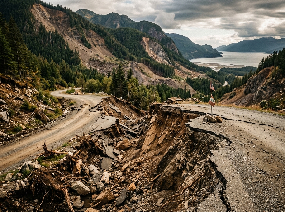
Buildings collapse. Roads split. Bridges fail. Hillsides slide. Electricity and water systems are disrupted. Fires can break out. Coastal earthquakes may displace the ocean floor and generate tsunamis capable of carrying destruction thousands of kilometers from the original earthquake.
Yet earthquakes are also an ordinary part of our dynamic planet. The U.S. Geological Survey estimates that roughly 500,000 detectable earthquakes occur worldwide each year; about 100,000 can be felt and around 100 cause damage.
For NaturePulse.net, earthquakes offer an important opportunity to combine authoritative seismic data with observations from ordinary people — creating a permanent geographic record of what happened, where it happened and how communities and landscapes were affected.
What Is an Earthquake?
The Earth's outer shell is divided into enormous pieces called tectonic plates. These plates move continuously, although usually so slowly that we cannot feel the movement. Where plates meet, rocks can become locked together while tectonic forces continue pushing or pulling them. Stress gradually accumulates. Eventually the rocks can no longer withstand the stress. They suddenly slip along a fault. Energy is released and travels through the Earth as seismic waves. The shaking produced by those waves is what we experience as an earthquake.
Hypocenter (Focus) — the point beneath the Earth's surface where the rupture begins.
Epicenter — the point on the Earth's surface directly above the hypocenter.
An earthquake therefore does not actually "start at the epicenter." It begins underground at the hypocenter.
Earthquakes Can Be Shallow or Deep
Shallow earthquakes can be especially destructive because the seismic energy has less distance to travel before reaching the surface. Deep earthquakes can occur hundreds of kilometers beneath the surface, particularly where one tectonic plate is being pushed beneath another at a subduction zone.
Depth matters enormously when assessing danger. A magnitude 6 earthquake very close to a city and only a few kilometers deep can sometimes produce more serious damage than a considerably larger but deeper earthquake farther away.
How Earthquake Magnitude Works
The magnitude scale is logarithmic rather than linear. Each whole-number increase represents about 10 times greater recorded wave amplitude and roughly 32 times greater energy release. The difference between a magnitude 6 and magnitude 9 earthquake is enormous.
The largest earthquake ever instrumentally recorded was the Great Chilean / Valdivia Earthquake of May 22, 1960 — magnitude 9.5. It generated a Pacific-wide tsunami.
Where Do Most Earthquakes Occur?
The Pacific Ring of Fire
The world's most important earthquake zone surrounds much of the Pacific Ocean — from Chile and Peru through Central America, Mexico, the U.S. West Coast, Alaska, the Aleutians, Kamchatka, Japan, the Philippines, Indonesia, Papua New Guinea, and New Zealand. USGS estimates approximately 81% of the world's largest earthquakes occur in the circum-Pacific seismic belt. Much of the Ring of Fire consists of subduction zones — one tectonic plate is being forced beneath another. These boundaries can remain locked for decades or centuries before suddenly releasing enormous amounts of energy.
The Alpide Earthquake Belt
Extends broadly from Southeast Asia toward Europe: Indonesia → Himalayan region → India → Pakistan → Afghanistan → Iran → Turkey → Mediterranean. Accounts for approximately 17% of the world's largest earthquakes.
Mid-Atlantic Ridge
Follows the Mid-Atlantic Ridge where tectonic plates are generally moving apart. Most of the ridge lies beneath the ocean, but Iceland sits directly on this system.
Countries and Regions Particularly Exposed
Japan — one of the world's leaders in earthquake preparedness. Modern Japanese buildings may incorporate flexible structures, seismic isolation, energy-dissipation systems, reinforced construction and automatic emergency systems. We cannot prevent earthquakes, but engineering can dramatically reduce their consequences.
Indonesia — one of the world's most seismically complex countries. The devastating 2004 Sumatra-Andaman earthquake and Indian Ocean tsunami demonstrated how an earthquake near one country can become an international catastrophe.
Philippines — within the Pacific Ring of Fire; contains numerous active faults and subduction zones.
China — the 1556 Shaanxi earthquake is recorded as the deadliest, with an estimated 830,000 deaths. The 1976 Tangshan earthquake killed hundreds of thousands.
Turkey — the North Anatolian and East Anatolian Fault systems pose substantial risks.
Iran — the 2003 Bam earthquake (magnitude 6.5) killed more than 40,000 people.
India — the Himalayan region is particularly important because the Indian Plate continues pushing into the Eurasian Plate. Higher-risk areas include Jammu & Kashmir/Ladakh, Himachal Pradesh, Uttarakhand, Northeast India, Bihar, Northern West Bengal, and the Andaman & Nicobar Islands.
Nepal — the 2015 Gorkha earthquake caused widespread destruction. Mountainous terrain adds landslide hazard.
Pakistan and Afghanistan — the magnitude 7.6 Pakistan earthquake of 2005 killed more than 80,000 people.
Chile — sits along one of Earth's great subduction zones. Produced the world's largest instrumentally recorded earthquake in 1960.
Peru and Ecuador — the same subduction system continues northward.
Mexico — large earthquakes hundreds of kilometers away can produce strong shaking in Mexico City because parts of the city were built on the sediments of an ancient lakebed. Soft sediments can amplify seismic shaking.
United States:
- Alaska — extraordinarily seismically active; the 1964 Great Alaska Earthquake measured magnitude 9.2, the largest in the U.S.
- California — the San Andreas Fault system accommodates movement between the Pacific and North American plates.
- Pacific Northwest — the Cascadia Subduction Zone. An estimated magnitude 9 Cascadia earthquake in 1700 produced a tsunami that reached Japan.
- Central and Eastern U.S. — the New Madrid earthquakes of 1811–1812 in Missouri and the Charleston earthquake of 1886 demonstrate that damaging earthquakes can occur far from famous seismic zones.
New Zealand — the country has invested substantially in earthquake science, building standards and public preparedness.
What Actually Causes Death During an Earthquake?
The shaking itself is rarely the direct cause of most deaths. USGS puts it clearly: much of the danger comes from buildings and their contents failing during shaking.
- Buildings collapse — unreinforced masonry, poorly constructed concrete buildings and structures not designed for lateral movement can collapse rapidly.
- Falling objects — shelves, cabinets, glass, ceiling materials, lighting, furniture, signs, masonry.
- Fires — earthquakes can rupture gas lines, electrical systems and fuel lines while damaged roads and broken water mains prevent firefighters from reaching them. The 1906 San Francisco earthquake is a classic example.
- Landslides — mountainous areas can experience thousands of landslides after a major earthquake.
- Liquefaction — some water-saturated soils can temporarily lose strength during intense shaking. Ground that normally supports buildings can begin behaving more like a liquid.
- Ground rupture — when a fault reaches the surface, the ground itself may be displaced.
- Dam and levee failure — creating secondary flooding risks even far from the epicenter.
- Infrastructure failure — a major earthquake can simultaneously damage roads, bridges, railways, airports, ports, hospitals, electricity, water, sewage, internet, cellular networks and gas pipelines.
Earthquakes and Tsunamis
A tsunami is a series of long waves produced by the displacement of a large volume of water. When an undersea earthquake suddenly raises or lowers the seafloor, the water above it is displaced. That disturbance spreads outward across the ocean.
Not every underwater earthquake produces a tsunami. Important factors: magnitude, depth, location, fault movement, and amount of vertical seafloor displacement. Most tsunamis are generated by earthquakes greater than magnitude 7 occurring beneath or close to the ocean and relatively near the Earth's surface. Approximately 89% of tsunamis in NOAA's Global Historical Tsunami Database were generated by large earthquakes or earthquake-triggered landslides.
The 2004 Indian Ocean Earthquake and Tsunami
On December 26, 2004, a massive magnitude 9.1 earthquake occurred off northern Sumatra. The tsunami radiated throughout the Indian Ocean — Indonesia, Thailand, Sri Lanka, India, Maldives — with waves exceeding 30 meters (about 100 feet) in some areas near the source. USGS cites a death toll exceeding 230,000.
The 2011 Japan Earthquake and Tsunami
On March 11, 2011, an enormous earthquake off northeastern Japan produced a tsunami that overwhelmed coastal communities and triggered the Fukushima Daiichi nuclear disaster. Natural disasters can trigger technological disasters.
The 1755 Lisbon Disaster
Earthquake, fires and tsunami affecting Portugal, Spain, North Africa and even the Caribbean. An estimated 50,000 people died. The disaster profoundly influenced European thinking about cities, science, philosophy and disaster preparedness.
Aftershocks and Foreshocks
A major earthquake is frequently followed by additional earthquakes. These are called aftershocks. Some can themselves be powerful. Buildings already weakened by the first earthquake may collapse during subsequent shaking. Aftershocks can continue for days, weeks, months — and following very large earthquakes, much longer.
A smaller earthquake before a larger one may later be identified as a foreshock. But at the time it occurs, scientists generally cannot know whether a particular earthquake is a foreshock or an ordinary earthquake.
Can Scientists Predict Earthquakes?
Not in the way people commonly imagine. Scientists can identify active faults, seismic hazard zones, historical patterns and long-term probabilities. But they cannot reliably say: "A magnitude 7.4 earthquake will occur here next Tuesday at 3:15 PM." Claims of precise earthquake prediction should be treated skeptically.
Earthquake Early Warning Is Different
Prediction and early warning are not the same. When an earthquake has already begun, seismic instruments can detect the initial waves and rapidly estimate the earthquake's location and magnitude. Electronic signals travel faster than destructive seismic waves — this can provide seconds of warning before stronger shaking reaches locations farther away. Those seconds can be valuable: warn people, stop trains, open fire-station doors, pause surgery, shut industrial systems.
Tsunami Detection
NOAA maintains coastal tide gauges and 39 deep-ocean stations. Data are transmitted by satellite and used to help detect and forecast tsunami activity. This is another example of why continuous observation matters.
The Natural Warning Signs of a Tsunami
For people near a coastline, technology should not be the only warning. If you experience strong or prolonged earthquake shaking, or notice sudden unusual withdrawal or rise of the sea, treat it as a potential tsunami warning. Move toward high ground or inland rather than waiting near the shore.
Why Similar Earthquakes Produce Very Different Disasters
Disaster severity depends on:
Magnitude × Depth × Distance × Local geology × Population × Building quality × Time of day × Preparedness × Secondary hazards.
A Role for NaturePulse.net
NaturePulse should not attempt to replace USGS, national geological agencies, NOAA or official emergency-warning systems. Instead, it can create a complementary global layer: The Human Observation Record.
Official instruments tell us magnitude, depth, latitude, longitude and origin time. People can tell us: the shaking lasted about 30 seconds here; books fell from shelves; the road cracked; a hillside collapsed; the river became muddy immediately afterward; power went out; water disappeared from the shoreline; this building was damaged; aftershocks are still being felt.
USGS already demonstrates the scientific usefulness of public observations through its Did You Feel It? program. NaturePulse could expand that citizen-observation philosophy globally and connect it to photographs, videos, landscapes and long-term environmental records.
NaturePulse Earthquake Observation
When someone reports an earthquake, automatically capture the date, local time, GPS coordinates, country, state/province, district/county, city/village and elevation. Then ask:
- Did you feel the earthquake? Yes / No
- How strong did it feel? Barely noticeable · Light · Moderate · Strong · Very strong · Violent
- Where were you? Inside · Outside · Vehicle · High-rise · Other
- What happened? Objects moved · Objects fell · Furniture moved · Windows broke · Walls cracked · Building damaged · Road damaged · Power outage · Water outage · Landslide · Liquefaction · Fire · Tsunami observed · Other
Photograph the Effects — Safely
NaturePulse should encourage photographs of ground cracks, damaged roads, fallen rocks, landslides, damaged buildings, fallen trees, changed streams and coastal changes. But safety must come first. Never encourage users to enter collapsed buildings, unstable slopes, damaged bridges, floodwater or tsunami zones merely to collect an observation.
Before → After → Recovery
Suppose NaturePulse already contains a photograph of a village from 2025. An earthquake occurs in 2027. Users photograph the same location — then again one month later, one year later, five years later. NaturePulse could preserve the complete transformation.
Earthquake Landscape Changes
Earthquakes don't affect only people and buildings. They can permanently change nature: raise coastlines, lower coastlines, redirect streams, create lakes, drain ponds, trigger landslides, alter groundwater, expose rock formations, change beaches, destroy forests, create new wetlands. NaturePulse could document these changes in ways conventional earthquake databases generally do not.
NaturePulse Could Become the Memory Layer
Seismographs are exceptionally good at measuring the physical earthquake. Satellites can measure landscape changes. Governments document casualties and infrastructure. News organizations document the immediate disaster. But much everyday evidence disappears. A photograph sits on someone's phone. A farmer remembers that a spring stopped flowing. A resident remembers when the hillside collapsed.
NaturePulse could preserve these observations permanently with:
Person + Place + GPS + Date + Time + Photo + Video + Story + Scientific Event.
That creates something different from an ordinary earthquake database. It creates a living environmental history of the event.
Earthquakes Remind Us That Earth Is Alive
We cannot stop tectonic plates from moving. We cannot prevent earthquakes. But humanity can become much better at monitoring, building, preparing, warning, evacuating, responding, learning — and remembering. And remembering matters.
A small observation made today may seem insignificant. But when millions of observations are accurately dated, geographically located and preserved across decades, they become part of humanity's collective record of a changing and dynamic planet.
NaturePulse.net — Observe · Record · Locate · Preserve · Learn.
What happened where you are? Record it today — because today's observation may become tomorrow's history.